OpenSKIZZE
Research project at a glance
Departments and Instituts
Funding type
Period
01.03.2024 to 31.08.2025


Project Description
The challenges of climate change make sustainable and climate-adapted planning and construction in cities essential. However, despite existing research and modeling approaches, such as ZURES and KliMoPrax, there is a lack of widespread implementation of these findings into practical construction projects. The reasons for this lie in the complexity of decision-making processes due to the many stakeholders involved, high time pressure, varying local conditions, a partial lack of expertise and data in early process steps, and high costs for expertise and software licenses.
OpenSKIZZE is intended to serve as an open-source AI assistant that transfers insights from climate models into concrete building projects. This system aims to involve all stakeholders early in the process and educate them on the impacts of their decisions on the local urban climate. OpenSKIZZE utilizes AI-driven optimization algorithms and machine learning to determine the effects of urban planning and architectural decisions on the climate and environment early in the planning and design phase. OpenSKIZZE does not only generate planning and design solutions; it also includes the visual preparation of results to enable a "common language" among all participants. This facilitates effective coordination between various actors. Through the use of machine learning, energy consumption is significantly reduced by requiring fewer simulation processes (by three orders of magnitude).
OpenSKIZZE is being evaluated on two specific construction projects by the Montag Stiftung Urbane Räume gAG and Neuer Stadtgärtnerei e.V. in Bonn. The partners provide expertise, process knowledge, and requirements analyses. The database has already been provided by the City of Bonn. The construction projects are located on the site of the old city nursery (Alte Stadtgärtnerei) in Bonn, which sits in a cold air inflow corridor. The goal is to design the development in such a way that cold air flow and heat radiation are optimized by the buildings to reduce the heat load in the adjacent residential area to the north, which is located in an Urban Heat Island (UHI). Various studies have proven that a reduction in UHI temperature leads to significant energy cost savings and a reduction in CO2 emissions.
The tools developed within the framework of this project will be freely accessible and will therefore have a multiplier effect for future applications. The application requests that the evaluation not only assess direct CO2 savings but also take future potential into account.
Step 1: Define the scope and climatic parameters
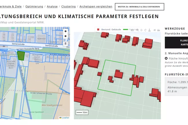
The planning area is selected on an interactive map. Parcel data is automatically loaded from the NRW geodata portal. Climatic parameters, such as the prevailing wind direction, are defined.
Step 2: Define performance characteristics and optimization goals
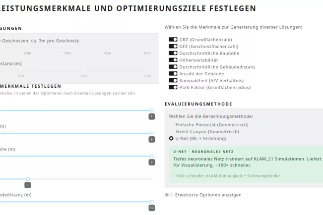
Users define structural boundary conditions (maximum building height, minimum building spacing) and select the desired design features — from the site occupancy index (GRZ) and floor area ratio (GFZ) to the proportion of green space. Various AI models are available for selection: SVGP (probabilistic), U-Net (flow-based), and a hybrid model.
Step 4: Results analysis
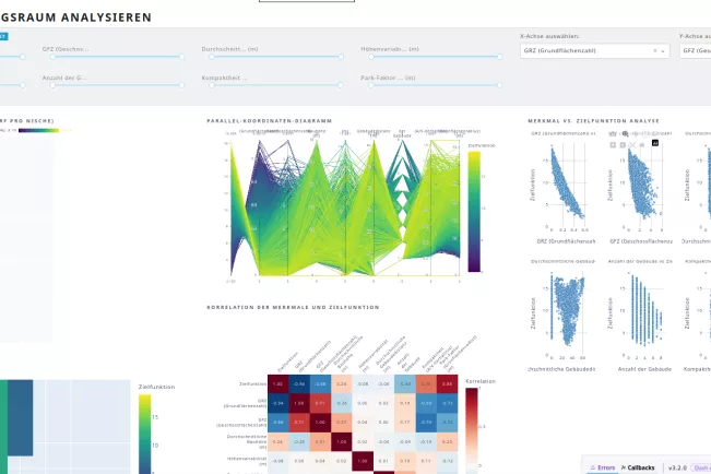
During the optimization (step 3), thousands of design variants are generated and then analyzed in step 4. The solution archive shows the best designs per feature combination with a 3D preview. Parallel coordinate diagrams and correlation analyses enable a deep understanding of the relationships between design parameters and climate impact.
Step 5: Clustering and design selection
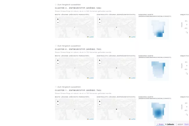
Similar design variants are automatically grouped into design types (clusters). For each type, the best solution, the most representative solution, and a consensus map are displayed. This reduces the complexity of thousands of variants to a manageable number of characteristic design types.
Step 6: Detailed comparison of selected designs
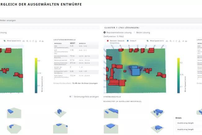
Selected design types are compared side-by-side — featuring 3D visualization of the buildings, flow fields (wind speed and direction), and a detailed table of all performance characteristics. A PDF report can be exported directly.
Cooperation partners
Sponsors
The Deutsche Bundesstiftung Umwelt is funding this project for the entire duration.